Hurricane Irma Discussion Number 40 - 颱風討論
By George
at 2017-09-09T11:49
at 2017-09-09T11:49
Table of Contents
Hurricane Irma Discussion Number 40
NWS National Hurricane Center Miami FL AL112017
1100 PM EDT Fri Sep 08 2017
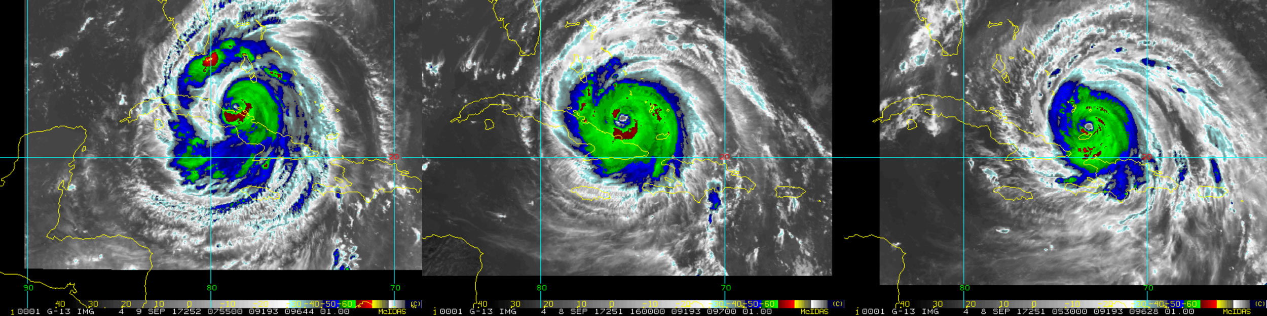
An Air Force Hurricane Hunter flight has found that Irma has
re-intensified to category 5 strength. The plane measured a
maximum flight-level wind of 154 kt and SFMR winds of 140-145 kt in
the northwestern eyewall, so the initial intensity is raised to 140
kt. The hurricane is producing very deep convection in all
quadrants around the eye, which the Air Force flight measured to be
35 n mi wide.
一架空軍颶風獵人機已發現Irma已重新增強為第五級強度. 此機測得
154節最大飛行高度風與在眼牆西北側140-145節的SFMR風風速
因此現行強度提升為140節.
此颶風正在風眼四周全象限產生非常深的對流,空軍機測量得出35海里寬
Apparently the ridge to the north of Irma has been stronger than
expected, and the initial motion remains westward, or 280/11 kt.
The track guidance continues to insist on Irma turning
west-northwestward soon, moving along the Cuban Keys adjacent to
the north coast of Cuba during the next 24 hours. After that time,
Irma is expected to turn sharply north-northwestward and accelerate
after 48 hours, moving parallel to the west coast of Florida and
then into Georgia. Mainly because Irma's eye has not deviated from
its westward motion, the new NHC forecast track has again shifted
slightly westward. Because of the hurricane's angle of approach to
the west coast of Florida, it is extremely difficult to pinpoint
exactly where the center might move onshore.
顯然的在Irma北邊的高壓脊比預期地要強,現行運動維持西行, 280度/11節
路徑指引持續堅持在二十四小時內Irma很快轉向西北西,沿著鄰近古巴礁島到古巴北海岸
此時間之後, 在四十八小時後Irma預期急轉北北西並加速,沿著佛州西海岸平行移動
並進入喬治亞州
主要因Irma風眼尚未偏離西向運行, 本中心新路徑預報再次稍微向西調整.
因為颶風的靠近角度靠向佛州西海岸, 這很非常困難去推定中心會向海岸何處實際移動
If the eye continues to move over the Cuban Keys and does not move
inland over the main island of Cuba, then Irma would likely not
lose much intensity during the next day or so. As we've stated
many times, fluctuations in intensity are likely during the next 36
hours due to possible and unpredictable eyewall replacement cycles.
After 36 hours, there are some indications that vertical shear may
increase over the hurricane, and a little more weakening is
anticipated at that time. Because of the concerns in the track
forecast noted above, Irma would be able to maintain a strong
intensity for a longer period of time if the center stays off the
west Florida coast. Regardless, Irma is still expected to be a
dangerous hurricane as it approaches the Florida Keys and the west
coast of Florida through 48 hours.
假如風眼持續在古巴礁島移動並不進入古巴島陸地, 那Irma應該在數日內
不太可能損失太多強度. 我們已強調很多次, 因無法預期的眼牆置換有可能會發生
強度有可能在接下來三十六小時內變動
在三十六小時後, 有些指示垂直風切也許會在颶風外增強, 預期在這時間點許些減弱
因在上述路徑預報中有這顧慮, 如果中心停留在佛州西海岸,
Irma應該可以維持強力的強度較長一段時間
無論如何, Irma仍預計是個危險的颶風,
在四十八小時前往佛州礁島群與佛州西海岸
(Message Keys與前報相同)
--
NWS National Hurricane Center Miami FL AL112017
1100 PM EDT Fri Sep 08 2017
An Air Force Hurricane Hunter flight has found that Irma has
re-intensified to category 5 strength. The plane measured a
maximum flight-level wind of 154 kt and SFMR winds of 140-145 kt in
the northwestern eyewall, so the initial intensity is raised to 140
kt. The hurricane is producing very deep convection in all
quadrants around the eye, which the Air Force flight measured to be
35 n mi wide.
一架空軍颶風獵人機已發現Irma已重新增強為第五級強度. 此機測得
154節最大飛行高度風與在眼牆西北側140-145節的SFMR風風速
因此現行強度提升為140節.
此颶風正在風眼四周全象限產生非常深的對流,空軍機測量得出35海里寬
Apparently the ridge to the north of Irma has been stronger than
expected, and the initial motion remains westward, or 280/11 kt.
The track guidance continues to insist on Irma turning
west-northwestward soon, moving along the Cuban Keys adjacent to
the north coast of Cuba during the next 24 hours. After that time,
Irma is expected to turn sharply north-northwestward and accelerate
after 48 hours, moving parallel to the west coast of Florida and
then into Georgia. Mainly because Irma's eye has not deviated from
its westward motion, the new NHC forecast track has again shifted
slightly westward. Because of the hurricane's angle of approach to
the west coast of Florida, it is extremely difficult to pinpoint
exactly where the center might move onshore.
顯然的在Irma北邊的高壓脊比預期地要強,現行運動維持西行, 280度/11節
路徑指引持續堅持在二十四小時內Irma很快轉向西北西,沿著鄰近古巴礁島到古巴北海岸
此時間之後, 在四十八小時後Irma預期急轉北北西並加速,沿著佛州西海岸平行移動
並進入喬治亞州
主要因Irma風眼尚未偏離西向運行, 本中心新路徑預報再次稍微向西調整.
因為颶風的靠近角度靠向佛州西海岸, 這很非常困難去推定中心會向海岸何處實際移動
If the eye continues to move over the Cuban Keys and does not move
inland over the main island of Cuba, then Irma would likely not
lose much intensity during the next day or so. As we've stated
many times, fluctuations in intensity are likely during the next 36
hours due to possible and unpredictable eyewall replacement cycles.
After 36 hours, there are some indications that vertical shear may
increase over the hurricane, and a little more weakening is
anticipated at that time. Because of the concerns in the track
forecast noted above, Irma would be able to maintain a strong
intensity for a longer period of time if the center stays off the
west Florida coast. Regardless, Irma is still expected to be a
dangerous hurricane as it approaches the Florida Keys and the west
coast of Florida through 48 hours.
假如風眼持續在古巴礁島移動並不進入古巴島陸地, 那Irma應該在數日內
不太可能損失太多強度. 我們已強調很多次, 因無法預期的眼牆置換有可能會發生
強度有可能在接下來三十六小時內變動
在三十六小時後, 有些指示垂直風切也許會在颶風外增強, 預期在這時間點許些減弱
因在上述路徑預報中有這顧慮, 如果中心停留在佛州西海岸,
Irma應該可以維持強力的強度較長一段時間
無論如何, Irma仍預計是個危險的颶風,
在四十八小時前往佛州礁島群與佛州西海岸
(Message Keys與前報相同)
--
Tags:
颱風
All Comments
By Frederica
at 2017-09-12T10:36
at 2017-09-12T10:36
By Emily
at 2017-09-15T09:24
at 2017-09-15T09:24
By John
at 2017-09-18T08:12
at 2017-09-18T08:12
By Erin
at 2017-09-21T06:59
at 2017-09-21T06:59
By Edith
at 2017-09-24T05:47
at 2017-09-24T05:47
By Robert
at 2017-09-27T04:35
at 2017-09-27T04:35
By Xanthe
at 2017-09-30T03:22
at 2017-09-30T03:22
By Xanthe
at 2017-10-03T02:10
at 2017-10-03T02:10
By Gary
at 2017-10-06T00:57
at 2017-10-06T00:57
By Olive
at 2017-10-08T23:45
at 2017-10-08T23:45
By Madame
at 2017-10-11T22:33
at 2017-10-11T22:33
By Ophelia
at 2017-10-14T21:20
at 2017-10-14T21:20
By Zanna
at 2017-10-17T20:08
at 2017-10-17T20:08
By Robert
at 2017-10-20T18:55
at 2017-10-20T18:55
By Lydia
at 2017-10-23T17:43
at 2017-10-23T17:43
By Catherine
at 2017-10-26T16:31
at 2017-10-26T16:31
By Yuri
at 2017-10-29T15:18
at 2017-10-29T15:18
By Necoo
at 2017-11-01T14:06
at 2017-11-01T14:06
By Zanna
at 2017-11-04T12:54
at 2017-11-04T12:54
By Todd Johnson
at 2017-11-07T11:41
at 2017-11-07T11:41
By Thomas
at 2017-11-10T10:29
at 2017-11-10T10:29
By Sarah
at 2017-11-13T09:16
at 2017-11-13T09:16
By Leila
at 2017-11-16T08:04
at 2017-11-16T08:04
By Susan
at 2017-11-19T06:52
at 2017-11-19T06:52
By Carolina Franco
at 2017-11-22T05:39
at 2017-11-22T05:39
By Olivia
at 2017-11-25T04:27
at 2017-11-25T04:27
By Tom
at 2017-11-28T03:14
at 2017-11-28T03:14
By Oscar
at 2017-12-01T02:02
at 2017-12-01T02:02
By Lydia
at 2017-12-04T00:50
at 2017-12-04T00:50
By Quintina
at 2017-12-06T23:37
at 2017-12-06T23:37
By Lydia
at 2017-12-09T22:25
at 2017-12-09T22:25
By Kristin
at 2017-12-12T21:13
at 2017-12-12T21:13
By Ophelia
at 2017-12-15T20:00
at 2017-12-15T20:00
By Belly
at 2017-12-18T18:48
at 2017-12-18T18:48
By Hedda
at 2017-12-21T17:35
at 2017-12-21T17:35
By Cara
at 2017-12-24T16:23
at 2017-12-24T16:23
By Bethany
at 2017-12-27T15:11
at 2017-12-27T15:11
By Rachel
at 2017-12-30T13:58
at 2017-12-30T13:58
By Zanna
at 2018-01-02T12:46
at 2018-01-02T12:46
By Blanche
at 2018-01-05T11:33
at 2018-01-05T11:33
By Olivia
at 2018-01-08T10:21
at 2018-01-08T10:21
By Quanna
at 2018-01-11T09:09
at 2018-01-11T09:09
By Harry
at 2018-01-14T07:56
at 2018-01-14T07:56
By Ina
at 2018-01-17T06:44
at 2018-01-17T06:44
By Eden
at 2018-01-20T05:32
at 2018-01-20T05:32
By Rachel
at 2018-01-23T04:19
at 2018-01-23T04:19
By Jacky
at 2018-01-26T03:07
at 2018-01-26T03:07
By Poppy
at 2018-01-29T01:54
at 2018-01-29T01:54
By Jack
at 2018-02-01T00:42
at 2018-02-01T00:42
By George
at 2018-02-03T23:30
at 2018-02-03T23:30
By Rebecca
at 2018-02-06T22:17
at 2018-02-06T22:17
By Tom
at 2018-02-09T21:05
at 2018-02-09T21:05
By Regina
at 2018-02-12T19:53
at 2018-02-12T19:53
By Anonymous
at 2018-02-15T18:40
at 2018-02-15T18:40
By Heather
at 2018-02-18T17:28
at 2018-02-18T17:28
By Zanna
at 2018-02-21T16:15
at 2018-02-21T16:15
By Delia
at 2018-02-24T15:03
at 2018-02-24T15:03
By Connor
at 2018-02-27T13:51
at 2018-02-27T13:51
By Puput
at 2018-03-02T12:38
at 2018-03-02T12:38
By Audriana
at 2018-03-05T11:26
at 2018-03-05T11:26
By Ethan
at 2018-03-08T10:13
at 2018-03-08T10:13
By Wallis
at 2018-03-11T09:01
at 2018-03-11T09:01
By Joseph
at 2018-03-14T07:49
at 2018-03-14T07:49
By Faithe
at 2018-03-17T06:36
at 2018-03-17T06:36
By Odelette
at 2018-03-20T05:24
at 2018-03-20T05:24
By Carol
at 2018-03-23T04:12
at 2018-03-23T04:12
By Noah
at 2018-03-26T02:59
at 2018-03-26T02:59
By Anonymous
at 2018-03-29T01:47
at 2018-03-29T01:47
By Erin
at 2018-04-01T00:34
at 2018-04-01T00:34
By Odelette
at 2018-04-03T23:22
at 2018-04-03T23:22
By Ursula
at 2018-04-06T22:10
at 2018-04-06T22:10
By Queena
at 2018-04-09T20:57
at 2018-04-09T20:57
By Olivia
at 2018-04-12T19:45
at 2018-04-12T19:45
By Iris
at 2018-04-15T18:32
at 2018-04-15T18:32
By Genevieve
at 2018-04-18T17:20
at 2018-04-18T17:20
By Wallis
at 2018-04-21T16:08
at 2018-04-21T16:08
By Edwina
at 2018-04-24T14:55
at 2018-04-24T14:55
By Poppy
at 2018-04-27T13:43
at 2018-04-27T13:43
By Hedwig
at 2018-04-30T12:31
at 2018-04-30T12:31
By Quanna
at 2018-05-03T11:18
at 2018-05-03T11:18
By Lily
at 2018-05-06T10:06
at 2018-05-06T10:06
By Vanessa
at 2018-05-09T08:53
at 2018-05-09T08:53
By Yedda
at 2018-05-12T07:41
at 2018-05-12T07:41
By Hamiltion
at 2018-05-15T06:29
at 2018-05-15T06:29
By Suhail Hany
at 2018-05-18T05:16
at 2018-05-18T05:16
By Rebecca
at 2018-05-21T04:04
at 2018-05-21T04:04
By Noah
at 2018-05-24T02:51
at 2018-05-24T02:51
By Kumar
at 2018-05-27T01:39
at 2018-05-27T01:39
By Sierra Rose
at 2018-05-30T00:27
at 2018-05-30T00:27
By Hedda
at 2018-06-01T23:14
at 2018-06-01T23:14
By Barb Cronin
at 2018-06-04T22:02
at 2018-06-04T22:02
Related Posts
又有颶風!緊跟「厄瑪」之後 「荷西」強
By Skylar Davis
at 2017-09-09T11:09
at 2017-09-09T11:09
天氣小觀:嚴密留意準泰利颱風! 模式接近台灣
By Ursula
at 2017-09-09T11:08
at 2017-09-09T11:08
Hurricane Irma Discussion Number 39
By Robert
at 2017-09-09T07:18
at 2017-09-09T07:18
20W形成 + GW
By Damian
at 2017-09-09T06:16
at 2017-09-09T06:16
Hurricane Jose
By David
at 2017-09-09T02:47
at 2017-09-09T02:47